
Boyko Nikolov – Bulgarian Military April 5, 2025
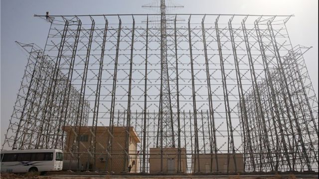
Iran’s Islamic Revolutionary Guard Corps Aerospace Force has been steadily expanding its network of “Ghadir” over-the-horizon early warning radars, with new construction sites identified in the northwest of the country near Tabriz and along the Persian Gulf coast.
These developments, recently highlighted by open-source intelligence analysts using satellite imagery from Google Maps and Google Earth, signal Tehran’s ongoing efforts to bolster its air defenses against potential threats, particularly from the United States or Israel.
The radars, designed to detect incoming strike aircraft, cruise missiles, and ballistic missiles at long ranges, represent a significant upgrade to Iran’s military infrastructure.
Iran has recently built a new Ghadir OTH radar about 140km NW of Tabriz https://t.co/oCPil7Y4Q1 along with a string of similar systems https://t.co/IqyMwkg1nN on the coast of the Persian Gulf https://t.co/AYvZnx0nY4 pic.twitter.com/2bAOnlqNSs
— Samir (@obretix) April 2, 2025
As tensions simmer in the Middle East, these installations could reshape the strategic calculus for any nation contemplating military action against Iran, while also raising questions about their true capabilities and the broader implications for the region.
The “Ghadir” radar system is no stranger to Iran’s defense landscape. First unveiled in 2011 during the Great Prophet 6 military exercises, it was officially introduced into service by the IRGC in 2012.
Developed domestically by the IRGC Aerospace Force’s Self-Sufficiency Jihad Organization, the Ghadir is a phased-array, three-dimensional radar with an advertised range of 1,100 kilometers—over 680 miles—for detecting ballistic missiles and 600 kilometers—about 373 miles—for aircraft.
Iranian officials, including Brigadier General Farzad Esmaili, then-commander of the IRGC’s air defense force, have claimed it can track stealth aircraft, cruise missiles, and even small drones, thanks to its ability to resonate frequencies and monitor targets at altitudes up to 300 kilometers.
In a 2014 statement to reporters in Tehran, Esmaili emphasized its resilience, noting that the system “can stand well against electronic warfare” and has a “minimal chance” of being detected or destroyed by anti-radar missiles, as reported by Iran’s state-affiliated Fars News Agency.
This combination of long-range detection and reported resistance to jamming makes it a cornerstone of Iran’s efforts to protect its airspace.
What sets the Ghadir apart from many conventional radar systems is its over-the-horizon capability, allowing it to detect threats beyond the curvature of the Earth. Unlike line-of-sight radars, which are limited by terrain and distance, over-the-horizon systems bounce radio waves off the ionosphere to see targets hundreds or even thousands of miles away.
The Islamic Revolutionary Guard Corps Aerospace Force (IRGCASF) is continuing its construction of “Ghadir” Over-the-Horizon Early Warning Radars in the northwest of the country and along the Persian Gulf, which would be used for advanced warning of strike aircraft as well as a… https://t.co/GNmo72Ju63
— OSINTdefender (@sentdefender) April 5, 2025
The Ghadir operates in the high-frequency band, likely around a 6-meter wavelength, which enhances its ability to spot low-flying or stealth objects that might evade shorter-wavelength systems. For comparison, the United States employs the AN/FPS-118 over-the-horizon radar, part of its Ballistic Missile Early Warning System, which can detect targets at ranges exceeding 3,000 kilometers.
Russia’s Rezonans-N, another over-the-horizon radar, boasts a similar range and has been exported to nations like Iran, where it complements domestic systems like the Ghadir.
While Iran’s radar may not match the sheer reach of its American counterpart, its design appears tailored to counter specific threats—namely stealth aircraft like the F-35 and low-altitude cruise missiles—that could be deployed by adversaries in the region.
The technical sophistication of the Ghadir is impressive, but its deployment locations reveal much about Iran’s strategic priorities. The new site northwest of Tabriz, geolocated by analysts at coordinates 38.756697, 44.955930, sits in West Azerbaijan Province, a rugged, mountainous area near the borders with Turkey and Iraq.
This placement leverages the region’s high elevation—some sites exceed 2,200 meters—to extend the radar’s line-of-sight range, while also positioning it to monitor threats from the west, a likely direction for U.S. or Israeli airstrikes.
Along the Persian Gulf, additional Ghadir installations dot the coastline, guarding vital shipping lanes and oil infrastructure that are both economic lifelines and potential targets. These southern sites, identified in satellite imagery shared by OSINT researchers like @obretix on X, are strategically placed to detect naval-based threats, such as carrier-launched aircraft or Tomahawk missiles from U.S. warships in the Gulf.
Together, these locations form a defensive arc, integrating with Iran’s broader air defense network, which includes Russian-supplied S-300 systems and domestically produced missile batteries.
Iran’s choice of these sites isn’t arbitrary. The northwest offers a natural barrier of mountains, complicating low-level penetration by enemy aircraft, while the Persian Gulf coast is a chokepoint for maritime traffic and a hotspot for military activity. Historically, Iran has viewed both regions as vulnerable.
During the Iran-Iraq War in the 1980s, Iraqi forces struck deep into western Iran, targeting cities and infrastructure. More recently, Israel’s October 2024 airstrikes on Iranian military facilities—including two Ghadir radar sites near the Iraqi border—demonstrated the real-world risks to these installations.
According to posts on X by @sentdefender, those strikes left Iran temporarily blinded to ballistic missile threats from the West, underscoring the radars’ role as high-value targets. Tehran’s response has been to accelerate construction, signaling a determination to close gaps in its defenses.
The open-source intelligence community has played a pivotal role in exposing these developments. Using commercially available satellite imagery, analysts have pinpointed exact coordinates and tracked construction progress, often sharing findings on platforms like X.
This transparency is a double-edged sword. On one hand, it provides unprecedented insight into Iran’s military buildup, allowing researchers and policymakers to assess its capabilities. On the other, it hands potential adversaries a roadmap to Iran’s defenses.
The question of who benefits from these disclosures is complex. Some speculate that leaks of precise locations—down to latitude and longitude—could be deliberate, orchestrated by nations opposed to Iran to facilitate targeting in a future conflict.
Others argue it reflects Iran’s confidence and willingness to showcase its technological prowess as a deterrent. Either way, the proliferation of OSINT has transformed modern warfare, turning publicly accessible tools like Google Earth into instruments of strategic significance.
—
Beyond their immediate military purpose, the Ghadir radars carry broader implications for the Middle East. Iran’s neighbors are watching closely. Turkey, with its own advanced military and NATO-aligned air force, might see the northwest radar as a check on its regional ambitions, particularly given tensions over Kurdish militias operating near their shared border.
Iraq, caught between Iran and the U.S., could find itself further entangled in any escalation, especially if American forces stationed there are perceived as a threat. Along the Gulf, Saudi Arabia and the United Arab Emirates—both equipped with U.S.-made Patriot systems and F-35 jets—may interpret Iran’s radar network as a step toward projecting power over the region’s critical waterways. The possibility of an arms race looms large, as these states bolster their own defenses in response.
Economically, the radars raise questions about Iran’s resource allocation. Under crippling U.S. sanctions, Tehran has struggled to fund its military ambitions. Yet the IRGC, which controls vast swathes of the country’s economy through front companies and illicit networks, has prioritized projects like the Ghadir.
A 2024 report by the Council on Foreign Relations notes that the IRGC’s financial empire generates billions, often bypassing sanctions to procure technology and materials. The radar’s domestic development—touted as a product of self-sufficiency—may also reduce reliance on foreign suppliers like Russia, though some analysts suggest Iran has adapted Russian designs, such as the Rezonans-N, to create the Ghadir.
What would an attack on these radars look like? History offers clues. In 2007, Israel’s Operation Orchard destroyed a Syrian nuclear reactor, using F-15s and electronic warfare to blind Syrian radar.
More recently, the October 2024 strikes on Iran involved F-35 stealth fighters, precision-guided munitions, and possibly drones, according to satellite imagery analysis by the Institute for the Study of War. A similar assault on the Ghadir sites might begin with cyberattacks to disrupt command and control, followed by low-flying F-35s evading detection until the last moment.
High-altitude B-2 bombers could deploy standoff weapons like the Joint Air-to-Surface Standoff Missile, while drones jam radar frequencies. The Ghadir’s elevated positions and over-the-horizon range might give Iran a few extra minutes of warning, but its fixed locations—now widely known—make it vulnerable to preemptive strikes.
Iran’s radar expansion reflects a nation bracing for conflict, but it also exposes the limits of its strategy. The Ghadir is a technological leap, capable of tracking advanced threats across vast distances, yet its effectiveness hinges on integration with missile defenses and fighter aircraft—areas where Iran lags behind the U.S. and Israel.
Compared to America’s networked Aegis system, which links radars, ships, and satellites in real-time, Iran’s defenses remain stovepiped, reliant on manual coordination. The radars may deter smaller-scale attacks, but against a determined foe with superior stealth and electronic warfare, their survival is uncertain.
Moreover, the psychological impact cuts both ways: while Iran projects strength, each new site becomes a target, amplifying the stakes in any future showdown.
The Ghadir’s rollout is a microcosm of Iran’s broader military evolution, blending innovation with defiance. For the United States, it’s a reminder that Tehran’s capabilities are growing, even under pressure.
For the region, it’s a potential catalyst for instability, as rival powers adjust their own postures. Whether these radars truly shift the balance—or simply invite more scrutiny—depends on how well Iran can protect them.
As satellite imagery continues to peel back the veil on military secrets, the world watches a high-stakes game unfold, where technology, geography, and geopolitics collide. Could this be the edge Iran needs, or just another flashpoint in an already volatile Middle East? Only time, and perhaps the next conflict, will tell.
Surely if this system can detect jets zapping along at Mach 2 then some lumbering yankee cruise missiles would be sitting ducks???
american people dont know what war is
they have no idea
they see the ruins of palestine on the internet and it does not sink in
when Nutenyahu said Today palestine tomorrow america ”
he meant just that
the word ” madoffed ” means to be bashed and robbed by jews
The USA will soon learn a bitter lesson
THE STOCKWEL STRANGLER
Kenneth Erskine was a black migrant serial killer who became known as The Stockwell Strangler. He committed the murders of 7–11 senior citizens in London between April and July 1986.His first victim was Nancy Emms, 78, of Wandsworth, who died on 9 April 1986. Her death was initially believed to have been due to natural causes and declared as such by an incompetent doctor on her death certificate. It was only established that she had been murdered when her home help noticed that her television set was missing from her flat. A post mortem examination revealed that she had been raped and strangled.
Although 11 rapes and murders are attributes to him, it is believed there were others
The police put out an identikit photo of a white man but another police officer noticed this and thought it matched crimes on his patch, plus the DNS on the bodies was of a black man with dreadlocks, edited out of the original identikit picture.
This pandering to political correctness may have cost the lives of several more elderly folk
and badly hindered the search for the killer
The biggest blunder, was the rapes of both elderly men and women that
were homosexual rapes, e g ” up the bum”
The police did not mention the rapes were homosexual and by a black man
this would have quickly narrowed down the search
and may have saved lives 1998 Edward Erskine was sentenced to 40 years in prison
Operation Globalist
Winston Churchill at the start of ww 2 said
“join up now and give Hitler a bloody nose
and you will come back toa land of milk and honey with jobs and homes for all”
A reason was concocted for the people, to break the treaty with Germany
and we went to war.
The British RAF would have 1000 bomber raids on the ruins of Germany,
then 20 minutes later when the rescue crews were out
the americans would then come through on their bombing raids.
Germany was just rubble
The gardener where Princess Diana went to primary school, Silfields told me the German men were all captured or killed and he was part of a flame thrower team, their orders were to kick in the cellar doors to the ruined buildings and give in a 30 second blast.
One cellar as he kicked in the door heard a baby crying, he shouted, “come out come out now”
and was shocked to see half starved filthy group of women all carrying babies or little tots
he then realised that his orders were in effect to kill the german womenfolk
The Russians were told to gang rape every woman between the ages of 8 and 80 leaving them with mixed race babies, to destroy the purity of the racial heritage.
The 2 rivers that ran by Berlin were said to have a continuous stream of dead women floating past.
OPERATION GLOBALIST was a gentler plan for the UK,
Rothschilds idea was to fill the UK with Blacks and browns dumb down UK women and let time take its course.
Churchill said to the armies being demobbed, there is not enough work here but you can go to australia an a ten pond passage where there is work, and thousands of men took the offer.
Next thing was the government advertised in the west indies saying
“come do the jobs the englishmen are too lazy to do”
and what was called ” protected professions ” were held open for the new comers
jobs on the railways buses hospitals coach drivers etc went them and our men who fought the governments war went on the dole,
The promised land of milk and honey with jobs and homes for all was not for our people
One hundred ex soldiers marched on parliamant but were stopped by police on one of the Thames bridges and turned back, many threw their medals in the thames.
There were riots in places like Notting Hill, this is why to this day there is an annual carnival for black folk there.
I still live in the area where most white folk have been ethnically cleansed, white folk are advised to stay home 2 days before the event during, and 2 days after, this led to the ex service men forming a political party called the National Front, an office opened up near me for people to enrol, the queue went all down the road and round the corner.
The government initiated a secret attack on supporters called operation globalism, every voting papar has a secret number, they know who you vote for, when you give your vote they hand you a pencil
this is often rubbed out and changed after and secret and very racist undercover attacks
were made, the Operation Twentymen, was to follow and discredit the main leaders of the new political party opposed to government racism.
Your government did this and the law of Positive discrimination for ethnics means the white folk are put behind, all these migrants pouring into the country is part of the rothschild governments plan
if government did not want them , they would not be here
The US sends ships, fighter jets and bombers across an ocean and a continent to menace Iran while Iran builds defensive systems to detect them. But Iran is the threat?
Hello i only just found this website
stumbled onto it by chance as i was looking for something else
its pretty damn good
but whats that idiot guy on about with the UK being run by natzis /
whats that about ? i dont get it
most experts say its almost totally a communist regime here now
Sky News halted for breaking announcement in damning blow to Keir Starmer
Story by Jess Phillips
Sky News was interrupted for a breaking news announcement as host Trevor Phillips interviewed the migrant Conservative Party leader Kemi Badenoch. Badenoch was being quizzed on her view of defence spending versus disability benefits, with Phillips reading a quote from shadow work and pensions secretary Helen Whately. The segment was accompanied by a breaking news strap across the screen which read: “Breaking News – Badenoch: Every country should control their borders”, and which was later changed to: “Badenoch: Retaliatory tariffs escalate trade war”.
The UK plays a game with its people we closed our borders in 2 world wars but say we cant now ?
they talk about money for defence, what defence the enemy is already inside the gates
imported in by government
With an operating wavelength of 6m it is capable of detecting “Stealth” aircraft. This has been known since Bosnia. The first thing the US will do is send terrain huggin Cruise Missles to destroy these installations. Or maybe the obrital Directed Energy Weapons since they’ve gotten so accurate from the
domestic targtet pracrtice of late.
Just Google “Tom Hanks House Safe”
Well maybe not Google but try Yandex 😉
@ no name welcome here
dont take any notice of the lad who writes about natzis hes just a welch twat
he barged about wearing pink bondage trousers which were then stolen from the washing line he says he likes an ocasional quick one up the bum
and likes the company of sheep…. enough said
as we say on here ” carl jones is the twattiest twat in twattendom >
Consider all this attention to an ever-increasing, impending military attack by America upon a country.
Consider that a military attack is an act of war.
Consider that Iran has not threatened to attack America, posses no danger to America.
Consider that Israel has threatened to attack Iran, repeatedly and repeatedly invoked a “mutual” need for America to be part of an attack upon Iran.
Consider that Israel has and is destroying, murdering and thieving land to expand itself, all the while being aided and abetted by America.
Consider that to sympathize with those subject to these combined attacks is then under an attack, not of a military nature, but of all the ways in which Israel and its International Conglomerate does so.
Consider how effective those ways of non-military war have been.
War destroys. The International Zionist Conglomerate is destroying some very fundamentals in America.
Can that not be obvious? Can that not be cause for alarm? Can that not be countered, to protect and preserve those very fundamentals of America?
The Israel propagandists will have you think otherwise. And that is a part of their goal.
Consider the ways in which it does so and you can understand the peril.
And Israel cares not for America. It cares for itself. And that is why…
Israel is not an ally to America. It is the opposite.